Making Maps and Management Plans
The latest news from Laura George who is working with Cheshire Wildlife Trust on a trainee placement, funded by the Saltscape Partnership:
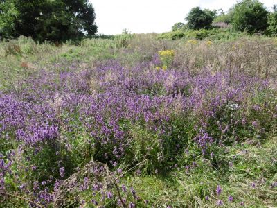
As part of the Saltscape project, we have been tasked to draw up management plans for some Local Wildlife Sites along the River Weaver. This means that we can provide helpful information and advice to landowners, from farmers to developers, on how best to manage their land for wildlife. One such site is the picturesque Acton Bridge Meadows. As you enter the site at the top of a steep slope you can see the Weaver winding its way in the distance and have a wonderful array of wildflowers before you, such as the purple flowering betony. At the base of this slope you come to the natural floodplain level, where you find an area of marshy wet grassland dotted with marsh marigold and ragged robin.
The process of formulating the management plan for Acton Bridge Meadows began back in June, when we undertook a botanical survey of the entire site. We collect species information to help us interpret what condition the site is in, for example certain wildflowers are very sensitive to nutrient enrichment and are therefore indicative of less disturbed sites. The results of the June survey informed us that one field on site had been unimproved (i.e. is still in a ‘natural’ state), but was in danger of being lost to encroaching scrub and more dominant species such as hogweed. Our identification skills were put to the test in another field because it had been heavily grazed by cattle, but from what was left we could tell that the land had restorable potential – so it’s not looking great now, but the soils are still good enough to support a species rich hay meadow…. with the right management of course.
The next stage was to draw up a Phase 1 Habitat Map. This involves transferring the survey data onto a site map, using standardised colour codes to annotate the different habitats. This is an essential part of providing management advice to the landowner, as it allows them to visualise the key areas which need attention and helps them to interpret the management recommendations.
Then we got down to the nitty-gritty of the management plan. We had to work out which features were most important on the site and how they could be better managed for the benefit of wildlife. For example, to stop the grassland disappearing, it would be best to re-introduce some form of conservation grazing, whereas the hay meadow would need a sympathetic cutting regime at the right time of year.
So there you have it, a management plan ready to go. And hopefully, the landowner can fit our suggestions in with their current management regime, and make another part of the Cheshire countryside better for wildlife.

